| |
Play
an adventure game
in Real-Life |
| |
Date
2003-08-27
Version
2.4
Author
Jeroen van de Merwe
|
| |
|
|
Masterprogam
of Mediatechnology, Leiden Institute of Advanced Computer Science, Leiden
University |
1. Abstract
 For my
graduation project, I built a game engine that runs on a Personal Digital Assistant
(PDA). Interfaced with a Global Positioning System (GPS)-device and a game description
file, a gamer can play an Adventure on and off the streets using his/her physical
presence to control the game character.
For my
graduation project, I built a game engine that runs on a Personal Digital Assistant
(PDA). Interfaced with a Global Positioning System (GPS)-device and a game description
file, a gamer can play an Adventure on and off the streets using his/her physical
presence to control the game character.
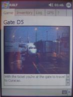
First a game description had to be loaded into the game engine. Then the game
starts. It begins at a certain starting position. From that point on, the gamer
finds himself inside an Adventure Game. It could be the gamer gets a voicemail
message containing a hint or the gamer has to be in the city center within 40
minutes. In that last case, the gamer has to go to that location in order to
receive a next hint or assignment.
Every location in the game is described in a game file. That file contains
all the information needed to run the game. Every location and every inventory
object is defined.
 Every
time the gamer is moving, the GPS-device gives the game engine new information
about the whereabouts of the gamer. When the gamer is in a known location, the
game engine checks the conditions where the gamer is in and then decides to
take action or not. An action could be the next assignment or a new hint for
the current assignment.
Every
time the gamer is moving, the GPS-device gives the game engine new information
about the whereabouts of the gamer. When the gamer is in a known location, the
game engine checks the conditions where the gamer is in and then decides to
take action or not. An action could be the next assignment or a new hint for
the current assignment.
To complete the whole assignment the gamer has to go to various locations throughout
an area and hopefully had the feeling to be part of the Adventure Game.
This article describes a platform for a new way of gaming; physically play
an Adventure Game with a virtual game character.
2.
Introduction
The project described in this paper was carried out as a graduation assignment
for the Masters program of Mediatechnology. The goal for the project was to
create something that involved:
- Creating a new interface;
- Other than standard interaction;
- Containing elements that are new territory for the graduation student and
the project has to be innovative; something we believe the education is trying
to accomplish.
2.1.
The Concept
Starting off with the project we formulated a few basic initial thoughts.
- It would be fun to develop a game
- Do something with ambiance-intelligence
(interact with or influence your surroundings)
- Using more than one technology in the project
- And (retro-) games like Leisure Suite Larry and Rick Dangerous came up
as inspiration for this project.
Together with the idea from the motion picture The Game [i] ,
the following concept was formulated:
Develop a real-life adventure game, where the gamer physically has to follow
a storyline in the real world surrounding him. For this purpose the gamer has
a kind of terminal that leads him through the game. The terminal runs the storyline,
handles the communication with the 'physical' world and reports to the user
on the progress made throughout the game.
To achieve this goal an outfit is created which holds the GPS-device and a
mobile computer that runs the game. The gamer gets an overall assignment. This
assignment can contain both virtual and physical concepts. For example the gamer
can be a gun-carrying mobster and also receive information about a real-world
building that he is passing during the game.
During the game the gamer gets various hints and new (sub) assignments through
various media. For example the gamer can get a telephone call that tells him
to go to a hotel in another city. The gamer than has to physically go to that
place in order to receive a new assignment or hint. Through use of the GPS (Global
Positioning System) module, it is verified that the gamer accomplishes this
task. When the game is running over multiple days, the gamer can also receive
messages or (fake) phone calls at a certain time when at home.
In short this idea for a Real-life Adventure Game is using multiple media to
inform and direct the gamer through an adventure game in the real world. Hopefully
the gamer experiences the game all around him/her.
2.2.
Project Goals
Right after the concept was formulated, we wanted to be able to play more than
the one game with it. We wanted to make it more universal, to reuse the technical
parts. The idea was to split the project in a file that described the game to
be played and software to interpret that game file.
The next goals were set for the project:
- Get the right hardware en get it to work with each other
- Develop a game engine and a game description language which defines a game.
- Parse the GPS output in ready to use data for the engine.
- Develop an example game with the game description for the graduation presentation
and demonstration purposes (see Appendix I).
3.
Technical overview
3.1.
Hardware
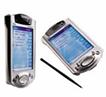
The gamer is equipped with a PDA, which runs the game engine. Therefore the
PDA had to be capable of linking with a GPS and playing sounds to simulate phone-conversations
or to give the gamer hints. Obviously there has to be a development environment
available for the PDA
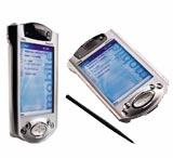
All of these criteria where found in the
Compaq 3800 series. That PDA runs the Pocket PC 2002 operating system.
For this O.S. there is a development environment on the Microsoft Website (see
references).
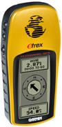
The GPS-device that is used in this project is the Garmin Etrex. To
connect the Etrex directly to the iPaq PDA there isn't a standard cable available,
but all parts needed to assemble such a cable are readily available in stores
or can easily be assembled. This makes the developed gaming system usable by
anyone and not just a lab-experiment. Both devices are handheld devices, making
it fully portable, which is important when playing the game.
To be able to reuse this technology, we decided to not make one game that can
be played, but to split the project in a game language and a game parser. This
way it's possible to create additional games with the same hardware and the
project is more universal. When a gamer has the technical components he can
install the game engine and setup a game himself.
To accomplish this, we had to have a game describing language and parsing software.
3.2.
Game language
To be able to play a game, the parts of a game should be known to the game
engine. Therefore a game is defined in a game language file.
To have full control over all things that the game engine has to be capable
of, we designed our own game description language. We looked at some existing
examples of game scripting languages, but they didn't meet our needs (see references).
Based on every possible scenario that we wanted the game engine to be running,
we made a list of things that needed to be in the game description:
- Some initialization variables and settings, such as the game name and a
start sound;
- Inventory objects;
- Location data;
- Conditions the user and the game have to meet, before the game continues.
These choices involved, writing a parser in the game engine to read the game
file. It is a lot of work to write a parser, but when implemented, it's easier
to change something in the game file structure and the parser than when you
use a standard format like XML.
On the other hand, using XML offers a lot of compatibility for interfacing with
other systems or platforms. But all things considered, we chose the new language.
The following is a brief example of a game file:
name = "Giving an example game file"
sound = main.wav
<inventory>
<object>
id = keycard
image = keycard.bmp
sound = keycard.wav
available = 0
</object>
<object>
id = cellphone
image = cellphone.bmp
sound = cellphone.wav
available = 1
</object>
</inventory>
<location>
id = atHome
name = Your workingroom
image = homeroom.bmp
sound = homeroom.wav
gpsLat = 4250.5589
gpsLong = 3221.5546
radius = 10
</location>
<question>
id = givTelNr
ask = Give the telephone number
type = open
answer = 0703325536
</question>
<conditions>
<if>
object = keycard, available:0
<then>
object = keycard, available:1
<else>
message = You already have a keycard!!
</if>
<if>
location = atHome
question = giveTelNr
<then>
message = Your calling credits are updated!
</conditions>
The variables at the top of the file are initialization variables. These describe
the name of the game, the start sound, etc. After that, the inventory is defined.
Between the <inventory> and </inventory> brackets
are the separate objects. Each object that is going to be in the game should
be defined in this section of the game file. An object is described by its
id, name, image, sound, value, what the object contains (for instance money
or credits) and availability (0 – not available or 1 – available).
After the inventory is defined the locations are defined by the <location>
and </location> brackets. A location is described by its id, name,
image, sound and its GPS-coordinates. When the GPS-device is very accurate with
the coordinates (see paragraph 3.4) the gamer has to be exactly on that position.
To be a little more flexible, a radius can be defined to a location. The gamer
than has to be in the radius of the given coordinates instead of being almost
exactly on that position.
Finally, the <conditions>. These describe all the conditions the
gamer has to meet to advance within the game. For instance, when a gamer enters
a location he has to have a keycard or cell phone. Otherwise the game engine
does not continue to the next assignment or hint. The gamer has to return to
a previous location to obtain the required object. Also the conditions describe
a time limit that is on a location. The gamer, for instance, has to be at a
location before a certain timeslot or should enter the location within 50 minutes
after arriving at the previous location.
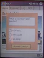
The gamer could also be asked a question as a condition. In this example the
gamer has to give the correct telephone number which is on a keycard. When the
gamer gives the correct answer, the game continues. Otherwise the gamer has
to go and look for the correct number.
There are two types of questions: open and multiple-choice. These are defined
by type (open or mc). If it is a mc question, three additional fields
are defined: aw1, aw2 and aw3. These are the possible answers that the gamer
can give. The correct answer is in the answer field (mc: 1, 2 or 3).
In the conditions, it's also possible to check values of inventory objects.
When an object has a value, a wallet for instance, that value can be checked
by using operators like "<" and ">". Using these,
it's possible to check if the wallet contains more than 20 dollars for instance.
There is also a possibility to setup time restrictions. The gamer can be faced
with a condition that he has to be on the next location within 30 minutes for
example. If he isn't he might be missing a clue or has to follow another route
to be able to complete the assignment. Other time restrictions are timer
and time. With timer it's possible to give a hint or next assignment
after xx minutes of arriving at the location. Time simply defines an action
that has to be executed when time and the actual time are the same.
Then there is a possibility to loose an inventory object. If you are for example
in a city where there's a lot of crime, there is a chance you could loose your
cell phone for instance. The odd that this could is defined in the game file
by random.
With all these elements, a game is described and now has to be loaded into
the game engine together with the mentioned image and sound files.
3.3.
Game engine
To create software that can load and execute a game file, we used the embedded
tools from Microsoft with Embedded Visual Basic (eVB). This version of Visual
Basic is a simplified version of Visual Basic 6. There a few differences in
usage that where important to the development:
- We could not use self defined classes in the code
- It's not possible to create new objects at runtime
- In the game we wanted to use images. The standard image object in eVB doesn't
support any other image types then BMP's. To be able to display these BMP's,
they have to be restricted to 8 bit indexed color images.
 Globally,
the engine (RALF) works as follows. First a game file is loaded. The file is
parsed to have the inventory, locations and conditions installed in memory.
When that is done, the starting point is loaded. This is the place where the
gamer begins his/her game. The engine reads the actual GPS-position and stores
that with the start position. When the gamer is instructed to go back to the
starting position, this is where the gamer has to go back to.
Globally,
the engine (RALF) works as follows. First a game file is loaded. The file is
parsed to have the inventory, locations and conditions installed in memory.
When that is done, the starting point is loaded. This is the place where the
gamer begins his/her game. The engine reads the actual GPS-position and stores
that with the start position. When the gamer is instructed to go back to the
starting position, this is where the gamer has to go back to.
After that, the GPS-device pushes new GPS-coordinates into the game engine every
second. Each time this happens, the current GPS-position is compared to the
coordinates of all the defined locations.
 When a match is found, the system loads that location and begins to check the
conditions that are applicable for that particular location. First there is
a time-check, has the gamer entered the location before a certain time or is
the location reached within the set number of minutes. When that condition is
met, the object conditions are checked. Does the gamer have a cell phone or
does an object contain a certain value. If those conditions also are met, a
question is asked to the gamer – if one defined. When the question is
answered correctly the actions that are defined are executed. This can be a
next hint or the next assignment.
When a match is found, the system loads that location and begins to check the
conditions that are applicable for that particular location. First there is
a time-check, has the gamer entered the location before a certain time or is
the location reached within the set number of minutes. When that condition is
met, the object conditions are checked. Does the gamer have a cell phone or
does an object contain a certain value. If those conditions also are met, a
question is asked to the gamer – if one defined. When the question is
answered correctly the actions that are defined are executed. This can be a
next hint or the next assignment.
If one of the conditions are not met, the else actions are executed. This could
mean a message saying the gamer has to go back to get an object or receives
a secondary assignment leading to a secondary storyline.
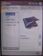 During
the game, the gamer can acquire new inventory objects or loose them. To see
what he has and how much it contains there is an inventory screen. This shows
every object that is in his possession.
During
the game, the gamer can acquire new inventory objects or loose them. To see
what he has and how much it contains there is an inventory screen. This shows
every object that is in his possession.
Other screens are:
- A log screen, showing every event that has occurred (object found or location
reached);
- A GPS screen, showing GPS information;
- An objective screen, to remind the gamer of his objective.
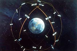
3.4. GPS protocol
Global Positioning System is a system that is developed by the American Ministry
of Defense. The system consists of 24 satellites, which are orbiting the earth
at an altitude of 19.000 kilometers.
These satellites are transmitting a signal, which contains time (UTC) together
with the location at which the satellite is positioned in relation to earth.
The receiver needs al least three signals to be able to locate the position
on the surface. With an optional fourth signal, it's possible to calculate height.
Depending on the weather conditions, the Etrex GPS-receiver can be accurate
up to 15 meters. Inside buildings it's hard to pickup any signal from the satellites,
so it's not possible to play a game inside a building.
When connected to the PDA, the GPS-device produces new GPS-data every second.
This is by a standard format that was designed by the The National Marine
Electronics Association (NMEA). This standard is the called the NMEA 0183
data protocol.
The following table shows the interpretation of the example:
$GPRMC, 092204.999,A,4250.5589,S,14718.5084,E,0.00,89.68,211200,,*25
| Field |
Example |
Comments |
| Sentence ID |
$GPRMC |
|
| UTC Time |
092204.999 |
hhmmss.sss |
| Status |
A |
A = Valid, V = Invalid |
| Latitude |
4250.5589 |
ddmm.mmmm |
| N/S Indicator |
S |
N = North, S = South |
| Longitude |
14718.5084 |
dddmm.mmmm |
| E/W Indicator |
E |
E = East, W = West |
| Speed over ground |
0.00 |
Knots |
| Course over ground |
0.00 |
Degrees |
| UTC Date |
211200 |
DDMMYY |
| Magnetic variation |
|
Degrees |
| Magnetic variation |
|
E = East, W = West |
| Checksum |
*25 |
|
| Terminator |
CR/LF |
|
4.
Similar Ideas
How does this project relate to similar projects and research carried out elsewhere?
After an extensive search on the internet we have found the following projects
to be related with ours some way or another.
4.1.
Spirit
Back in 1997 a group of students at the Uppsala University did a project with
the name Spirit. The goal of this project was to build a location aware
information system. The system is able to feed information to a person on foot
in a city environment.
The system was built using portable modules and a central server. The portable
equipment consists of a GPS-device, a PDA and two cell phones. One cell phone
is used for the data communication and the other is used for audio communication.
All of the portable modules are connected to the central server.
Then the GPS-device communicates his position every time to the central server.
The server then associates available information sources with the real-world
objects near to the user and presents that information to the user as speech.
Extra information is given to the user through the PDA by images.
To demonstrate this system, the students have implemented an Adventure Game.
In this game two contestants have to search for clues to solve a puzzle. The
contestants sometimes have to be at different locations to solve the puzzle.
The Spirit project is described on http://www.csd.uu.se/projects/spirit97/
This idea is very similar to the current project. Only the starting points
are different. They start from a more information based point of view, whereas
our project originated in the idea to create a Real-life Adventure Game.
Also the Spirit variant to the Adventure Game cannot be played by a single person.
The power of the RALF project is that the gamer can play an Adventure Game and
depends on nobody to be able to complete the game, because the game is running
on the PDA and doesn't need a server, making it very portable and easy to play.
4.2.
GeoVector – Play Doom on the streets
We also found this similar - more recent - development. The article to follow
is quoted from a New Zealand website [ii]
Japanese mobile phone users could be taking to the streets
early next year to play shoot-it-up computer game Doom – thanks to technology
developed in New Zealand.
GeoVector develops location-based services – using
pointing technology. This lets people get information about objects, such as
buildings, simply by pointing a mobile phone at them.
Pointing a phone at a movie theatre could, for example,
prompt information about what films it was showing to be displayed on screen,
along with viewing times and ticket prices.
Another application under development would let
people point their phones to see if friends – with similarly equipped mobiles
– were nearby.
Using this technology they are planning to create Real-life Doom. This new
technology …
… lets mobile phone users battle it out with one another
on the streets, using their phones to zap opponents and the screens on their
mobiles to view the Doom environment.
To be able to give the information to the user who points to the building or
statue, the information is stored somewhere. That part is similar to the RALF
project. RALF is able to link information to the current position of the gamer
and provides the gamer with it. The only difference is that the data is on the
PDA itself and not, like this project, on a central server somewhere.
4.3.
GPSter – Waypoint Sharing
Then we recently heard about this project: GPSter. The basic idea of this project
is to leave messages, images, audio, video or other links at a specific GPS-location
for the next person who comes to that place.
The idea behind it is that everybody, in the near future, has access to mobile
internet. When he comes to a location, it’s possible there is a message or some
audio for him to read or listen to. It's also possible to leave something behind
for the next person. All this information is stored on a central server in a
database. The database is accessed through a unified format and also provides
a link to already existing waypoint databases like geoURL (http://www.geourl.org).
This idea has the most similarities of the three ideas mentioned in this chapter.
The RALF game-engine also works with waypoint data and accesses the data only
when the gamer is on the defined waypoint. The only difference is, just like
the previous idea, that the data is located on the engine running device instead
of a central server.
4.4.
Overall
I think these three examples, with the RALF project, illustrate where the development
is going in the future. It will spark a whole new kind of game types and a whole
new game atmosphere.
5.
RALF in the future …
Having done this project and the current realization, there are things to be
done in the future to create a bigger and better application:
- In the present version it isn't possible to play (small) movie files. This
is due to a limitation of the development software in the current version.
Maybe in a future version or with an external library it can be done.
- The game description file is currently written in a standard text-editor,
which makes it prone to typing and structural errors. A simple point-and-click
game-development application would solve these problems.
- To induce widespread use of our engine, there is an idea to create a webserver
that creates, hosts and sends the game files to the gamer's PDA. With this
construction it's possible to get new updates for the game engine and several
game files.
- To get closer to the original idea, the technology used has to be expanded.
For instance the mentioned game server has to serve actual phone calls to
the gamer's cell-phone to provide hints and messages. These are faked right
now with a voicemail. So for the whole experience, the gamer has to have the
idea he is really part of a game. Like the motion-picture The Game
which sparked the idea for this project.
- Another possibility than can be explored is to make the game engine multiplayer.
That involves the game server also to handle game play of the two players.
The server has to monitor the player's positions and actions and act on that
information.
6.
Acknowledgements
I'd like to put my thanks out to:
- Masterprogram of Mediatechnology, Leiden Institute of Advanced Computer
Science, Leiden University
for providing the location for Mediatechnology, at which I spent a lot
of great times during the various courses
- Maarten Lamers
for all the coaching, support and for the input which kept the project
running
- Multimax Electronics B.V., Bilthoven, The Netherlands (http://www.multimax.nl)
for providing the GPS receiver free of cost during the development of
the project
- Martine Roeleveld
for the support and providing information about Mediatechnology
- Bas Haring
for the support and admitting me to the first run of Mediatechnology
- Bjﺉrn and John of Foobar
for delaying the start date of our business
- And all the other people
who encouraged me to do this project and helped me believe I could do
this.
Contact information:
7.
References
7.1.
Books
Pocket PC, Handheld Pc –
Developers Guide with Microsoft eMbedded Visual Basic
Grattan, Nick
Prentice Hall PTR, 2002
ISBN 0-13-065077-3
Teach Yourself Visual Basic in 24 hours
Perry, Greg
Hettihewa, Sanjaya
Sams Publishing, 1998
ISBN 0-672-31533-5
Visual Basic Programmer's Guide to Serial Communications, 3rd Edition
Grier, Richard
Mabry, 2003
ISBN 1-890422-27-4
7.2.
Internet links
Handheld development, Using the eVB COMM control
http://www.devbuzz.com/content/zinc_evb_comm_control_pg1.asp
Knechtges, David
deVBuzz.com Inc., 2000-2001
Handheld development, eVB Treeview control and ImageList control
http://www.devbuzz.com/content/zinc_addNode_TreeView_Imagelist_pg1.asp
Mitchell, Carole
deVBuzz.com Inc., 2002-2003
Guidelines for Developing Successful Games
http://www.gamasutra.com/php-bin/login.php3?from=/features/20010815/shelley_01.htm
Shelley, Bruce
gamasutra.com, 2001
Playing a Wav-file tutorial
http://www.justppc.com/evb6.shtml
Saeed, Omar
justppc.com, 2001
Implementing a Non-Linear Story
http://www.gamedev.net/reference/articles/article244.asp
Howland, Geoff
Gamedev.net, 1999
Game Design: The Essence of Computer Games
http://www.lupinegames.com/articles/essgames.htm
Howland, Geoff
lupinegames.com
7.3.
Other Game describing languages
QuestML
http://questml.com
AXE's Quest, using Adventure Scripting Language (ASL) 3.11
http://www.axeuk.com/quest
7.4.
Develop environment
eMbedded Visual Tools Downloads and Samples
http://msdn.microsoft.com/vstudio/device/embedded/download.aspx
7.5.
Similar Ideas
Spirit
http://www.csd.uu.se/projects/spirit97/
GeoVector
article on Stuff >> Infotech
http://stuff.co.nz/stuff/0,2106,2547152a28,00.html
Pressinfo from GeoVector
http://www.geovector.com/press/pocketdoom.html
GPSter
http://www.gpster.nl
8.
Appendix I: A sample story line
This is the sample storyline that I made for the presentation on august 28th:
There are a few diplomas that are lost for the graduation ceremony on Friday.
They seem to be on the parking lot. You have to find them and bring them to
Martine.
This is the code to make the story work with the engine:
'made by Jeroen van de Merwe, august 27, 2003
title = Verloren bullen!
message = Er schijnen een aantal bullen voor de uitreiking morgen op het parkeerterrein
te liggen ...\n\nGa die bullen zoeken.
log = Game started ...
startpoint = huygens
<inventory>
<object>
id = map
name = Verloren Bullen
image = bullen.bmp
available = 0
</object>
</inventory>
<location>
id = huygens
name = Huygenslab
image = huygens.bmp
gpsLat = 5210.1270
gpsLong = 00427.4880
radius = 100
message = Je bent nu in het Huygens laboratorium. Ga de bullen zoeken ...
log = In het Huygenslab
</location>
<location>
id = liacs
name = Liacs
image = liacs.bmp
gpsLat = 5210.1750
gpsLong = 00427.4360
radius = 150
message = Je bent aangekomen bij het LIACS gebouw, vraag aan de balie naar
de bewuste persoon
log = Bij het LIACS
</location>
<location>
id = bus
name = Bushalte
image = bus.bmp
gpsLat = 5210.2170
gpsLong = 00427.5150
radius = 100
message = Bij het bushokje, ben je nog op tijd?
log = Bij het bushokje
</location>
<location>
id = parking
name = Parkeerterrein
image = parking.bmp
gpsLat = 5210.1860
gpsLong = 00427.4780
radius = 100
message = Op het parkeerterrein, kan je de bullen vinden?
log = Op het parkeerterrein
</location>
<question>
id = vraagNaam
location = liacs
ask = Naar wie bent U op zoek?
answer = Martine
type = open
</question>
<conditions>
<if>
location = parking
object = bullen, available:0
<then>
object = bullen, available:1
message = Je hebt de verloren bullen gevonden, breng ze nu naar Martine
in het LIACS gebouw.
log = bullen gevonden
runcount = 1
</if>
<if>
location = liacs
object = bullen, available:1
question = vraagNaam
<then>
message = Martine is net weg, ze ging de bus richting het Centraal Station
halen.
log = Martine is net weg
runcount = 1
<else>
message = Persoon is hier niet bekend
log = Persoon niet bekend
</if>
<if>
location = bus
object = bullen, available:1
maxtime = 5
prevlocation = liacs
<then>
message = Je hebt het op tijd gered, Martine heeft nu alle bullen voor morgen.
log = gehaald, spel afgelopen
runcount = 1
<else>
message = Je bent niet op tijd, Martine is al met de bus weg. Neem de bullen
nu zelf maar mee morgen
log = niet gehaald, bullen zelf meenemen
runcount = 1
</if>
</conditions>
[i] IMDb.com movie database tagline: "Wealthy financier Nicholas Van Orton
gets a strange birthday present from wayward brother Conrad: a live-action
game that consumes his life."
[ii] http://stuff.co.nz/stuff/0,2106,2547152a28,00.html